Understanding Topographical Surveys: An Essential Guide
Topographical surveys are vital tools in modern construction and land development projects, providing essential insights into the natural and man-made features of any given land. These detailed surveys encompass a range of crucial information, from elevation changes to the locations of existing structures, ensuring that architects, engineers, and planners can make informed decisions. As we dive deeper into the world of Topographical surveys, we will explore their unique characteristics, uses, and the myriad of technological advancements propelling this field forward.
What are Topographical Surveys?
A topographical survey is a precise, detailed representation of a parcel of land, showcasing both its natural features and any man-made structures. This type of survey is essential for many sectors, including construction, engineering, and urban planning. By employing advanced surveying techniques, a topographical survey captures critical information such as:
- Elevation changes
- Contour lines
- Water bodies
- Vegetation types
- Existing infrastructure (roads, buildings, utilities)
With this information, professionals can create accurate maps and 3D models of land, facilitating effective design and planning processes.
Common Uses and Applications of Topographical Surveys
Topographical surveys serve a wide range of applications, including but not limited to:
- Construction Projects: Essential for obtaining accurate site data to inform construction plans.
- Environmental Studies: Help in assessing potential impacts of construction on existing ecosystems.
- Urban Planning: Assist authorities in planning developments that comply with local regulations.
In essence, these surveys provide foundational data for various types of projects, ensuring compliance and function meet the terrain’s characteristics.
Differences Between Topographical Surveys and Other Survey Types
While topographical surveys focus on the detailed features of a specific land area, other survey types, such as boundary or cadastral surveys, primarily define property lines and ownership. Understanding these differences is crucial for choosing the appropriate survey for your project. For example, while a boundary survey can help clarify land ownership disputes, a topographical survey is necessary for creating functional designs suited to the terrain.
Why Topographical Surveys are Crucial for Your Project
The accuracy of a topographical survey can significantly shape the outcome of your project. By understanding the landscape, stakeholders can unlock a series of advantages that contribute to project success.
Identifying Natural Features and Site Challenges
One of the primary benefits of conducting a topographical survey is the identification of natural features that may pose challenges during construction. From flood zones to unstable ground, understanding these elements early in the planning process allows for better risk management and mitigation strategies. This foresight is particularly essential in preventing future complications and costly delays.
Supporting Planning Permissions and Applications
In the UK, local authorities often mandate the submission of topographical surveys alongside planning applications. These documents demonstrate that proposed developments align with existing environmental and legal conditions. This requirement underscores the importance of thorough survey work in making the approval process smoother and more efficient.
Mitigating Risks and Avoiding Costly Errors
Topographical surveys can prevent costly errors by ensuring that all stakeholders have access to reliable data about the land. Inaccurate or incomplete information can lead to structural problems, necessitating rework, which can dramatically inflate project costs. A high-quality topographical survey lays the groundwork for informed decision-making, ultimately safeguarding your investment.
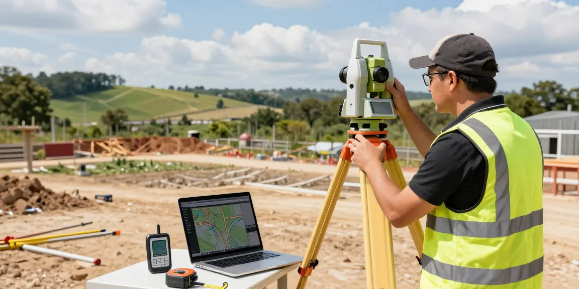
Equipment and Technology in Topographical Surveys
The landscape of surveying has transformed dramatically in recent years, with technological advancements enabling surveyors to achieve unprecedented levels of accuracy and efficiency. Here’s a look at some of the advanced tools used in modern topographical surveys.
Advanced Tools Used in Modern Topographical Surveys
Modern topographical surveys rely on state-of-the-art technology, enabling surveyors to gather and analyse data with remarkable precision. Key equipment includes:
- Total Station Instruments: Used for measuring angles and distances, combining traditional theodolite functions with electronic distance measurement.
- GPS Surveying Equipment (GNSS): Delivers rapid and accurate point positioning, especially useful in expansive or rural locations.
- 3D Laser Scanners (LiDAR): Capable of collecting millions of data points per second, ideal for rendering complex terrains.
- UAVs (Drone Surveys): Equipped with high-resolution cameras for mapping inaccessible areas, offering a bird’s eye view of the land.
- Digital Level Instruments: Used for measuring vertical changes in terrain, ensuring accuracy in elevation data.
Software Solutions for Survey Mapping and Analysis
In addition to hardware, sophisticated software plays a crucial role in the processing and analysis of survey data. Programs designed for CAD integration and Building Information Modelling (BIM) streamline the workflow, allowing for more straightforward interpretation and application of survey findings.
Leveraging Drones for Enhanced Survey Accuracy
Drones have emerged as a game-changer in the surveying industry, providing high-resolution aerial imagery and data collection that is faster and often more cost-effective than traditional methods. Their ability to access difficult terrains enhances the accuracy of the survey while reducing the time required to complete the job.
The Process of Conducting a Topographical Survey
Understanding how topographical surveys are conducted is crucial for stakeholders involved in construction and land development. The survey process typically unfolds in three main phases: preparation, execution, and post-survey analysis.
Pre-Survey Preparation: Planning and Site Visits
The first step involves thorough planning, including site visits to assess conditions and understand the specific needs of the project. Experienced surveyors will evaluate the area and identify any potential obstacles, such as vegetation or existing structures, that may influence the survey’s execution.
Carrying Out the Survey: Methodologies and Techniques
During the survey, a combination of techniques is employed, including traditional measuring methods and advanced technology. Data is collected and documented with utmost precision, ensuring that all relevant features, both natural and man-made, are captured.
Post-Survey Analysis: Deliverables and Reporting
After data collection, the next phase involves analysing the information and preparing comprehensive reports. Deliverables often include detailed topographical maps, digital models, and reports formatted for various applications like CAD integration or for use in regulatory submissions, ensuring stakeholders have the necessary tools to move forward.
Cost Considerations for Topographical Surveys in 2026
Understanding the cost of topographical surveys is essential for budgeting and planning purposes. Various factors can influence the pricing structure, leading to a wide range of potential costs.
Factors Influencing Topographical Survey Pricing
Several elements can impact the overall cost of a topographical survey, including:
- Size and complexity of the site
- Level of detail required
- Accessibility issues
- Geographic location
A thorough understanding of these factors can help clients make informed decisions when selecting surveying services.
Understanding Quotes: What to Expect in Your Estimate
When seeking a quote for a topographical survey, it’s essential to consider the scope of work outlined by the surveying company. Expect clear breakdowns of costs, including any additional fees for services outside the standard package. Having a detailed quote ensures transparency and helps prevent unexpected expenses later in the project.
Finding Value: Comparing Costs Across Providers
With various surveying companies available, comparing costs is vital. It’s essential to weigh the price against the quality and range of services offered. Look for providers with proven experience and a reputation for accuracy, as this often translates to long-term value.
How much is a topographical survey?
In the UK, topographical survey costs can vary widely based on the aforementioned factors. Typically, you can expect small residential plots to range from £450 to £750, while larger commercial or infrastructure sites may start from £1,500 and go upwards. Obtaining multiple quotes can help you identify a fair market rate for the specific services you require.
Do I need a topographical survey?
For anyone considering a construction project, a topographical survey is usually an essential step. The data provided not only informs design decisions but is often a requirement for planning permissions and compliance with local regulations.
What is shown on a topographic survey?
A topographical survey typically displays a variety of landscape features including:
- Elevation contours
- Natural terrain features like hills and valleys
- Human-made structures such as buildings and roads
- Water bodies, vegetation, and other ecological features
By providing this detailed information, topographical surveys serve as foundational tools in the planning and execution of land development projects.